Groundwater recharge in highly-fractured volcanic aquifers remains poorly understood in the humid tropics, whereby rapid demographic growth and unregulated land use change are resulting in extensive surface water pollution and a large dependency on groundwater extraction. Here we present a multi-tracer approach including δ18O-δ2H, 3H/3He, and noble gases within the most prominent multi-aquifer system of central Costa Rica, with the objective to assess dominant groundwater recharge characteristics and age distributions. We sampled wells and large springs across an elevation gradient from 868 to 2,421 m asl. Our results suggest relatively young apparent ages ranging from 0.0±3.2 up to 76.6±9.9 years. Helium isotopes R/RA (0.99 to 5.4) indicate a dominant signal from the upper mantle across the aquifer. Potential recharge elevations ranged from ~1,400 to 2,650 m asl, with recharge temperatures varying from ~11°C to 19°C with a mean value of 14.5±1.9°C. Recharge estimates ranged from 129±78 to 1,605±196 mm/yr with a mean value of 642±117 mm/yr, representing 20.1±4.0% of the total mean annual rainfall as effective recharge. The shallow unconfined aquifer is characterised by young and rapidly infiltrating waters, whereas the deeper aquifer units have relatively older waters. These results are intended to guide the delineation and mapping of critical recharge areas in mountain headwaters to enhance water security and sustainability in the most important headwater dependent systems of Costa Rica.

Leia Mayer-Anhalt

and 3 more

There is still limited understanding of how waters mix, where waters come from and for how long they reside in tropical catchments. In this study, we used a tracer-aided model (TAM) and a gamma convolution integral model (GM) to assess runoff generation, mixing processes, water ages and transit times (TT) in the pristine humid tropical rainforest Quebrada Grande catchment in central Costa Rica. Models are based on a four-year data record (2016 to 2019) of continuous hydrometric and stable isotope observations. Both models agreed on a young water component of fewer than 95 days in age for 75% of the study period. The streamflow water ages ranged from around two months for wetter years (2017) and up to 9.5 months for drier (2019) years with a better agreement between the GM estimated TTs and TAM water ages for younger waters. Such short TTs and water ages result from high annual rainfall volumes even during drier years with 4,300 mm of annual precipitation (2019) indicating consistent quick near-surface runoff generation with limited mixing of waters and a supra-regional groundwater flow of likely unmeasured older waters. The TAM in addition to the GM allowed simulating streamflow (KGE > 0.78), suggesting an average groundwater contribution of less than 40% to streamflow. The model parameter uncertainty was constrained in calibration using stable water isotopes (δ2H), justifying the higher TAM model parameterization. We conclude that the multi-model analysis provided consistent water age estimates of a young water dominated catchment. This study represents an outlier compared to the globally predominant old water paradox, exhibiting a tropical rainforest catchment with higher new water fractions than older water.
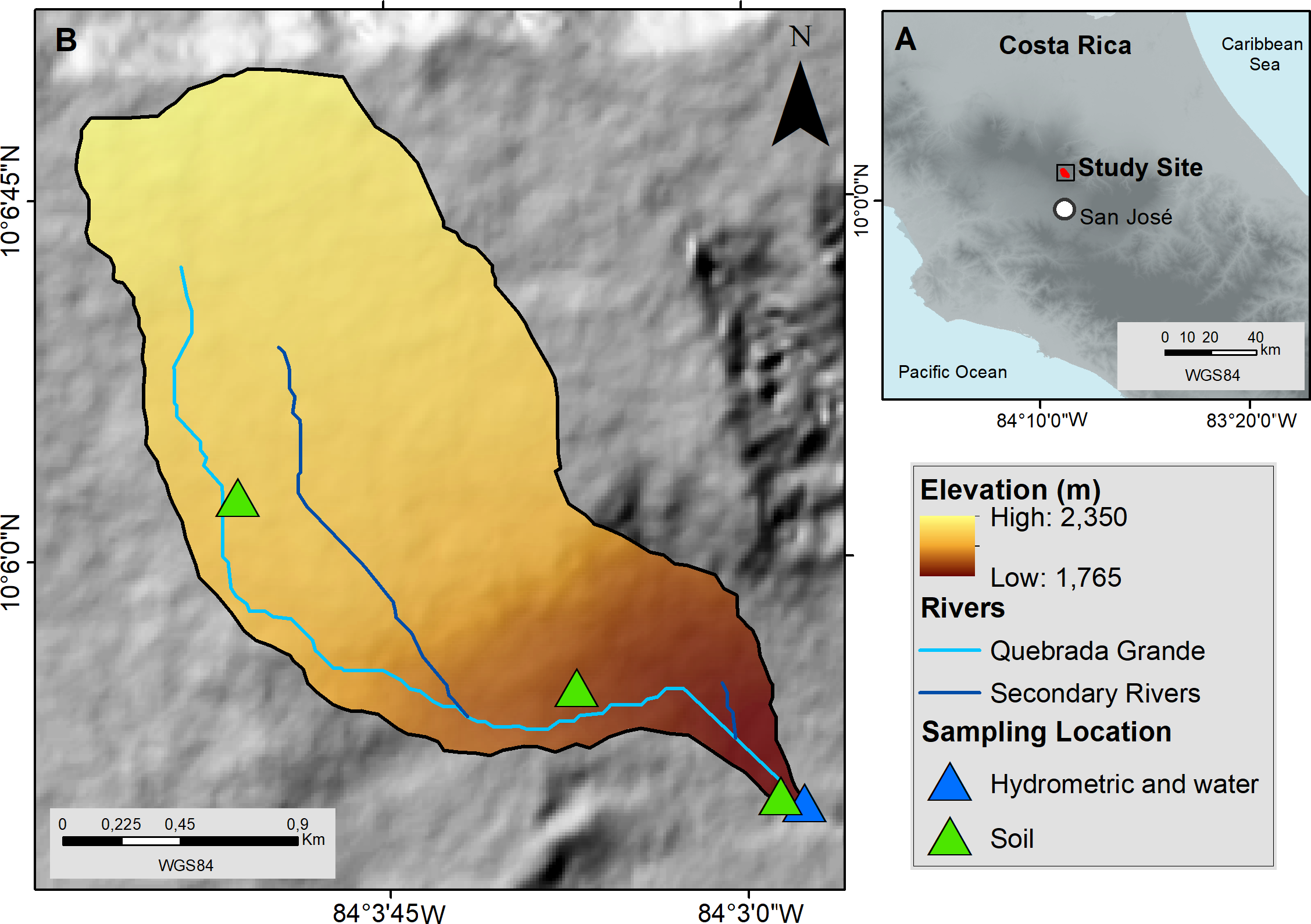
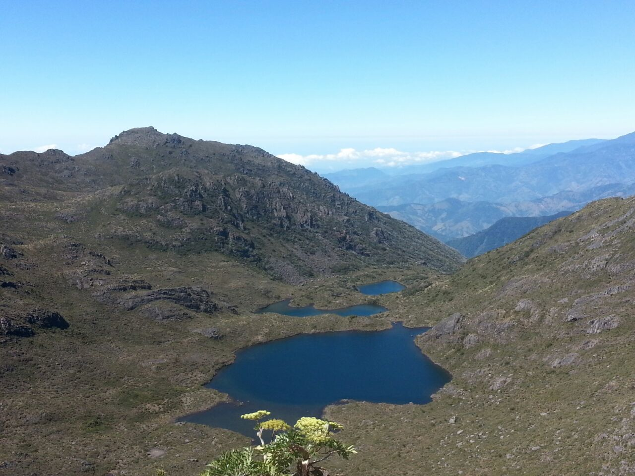
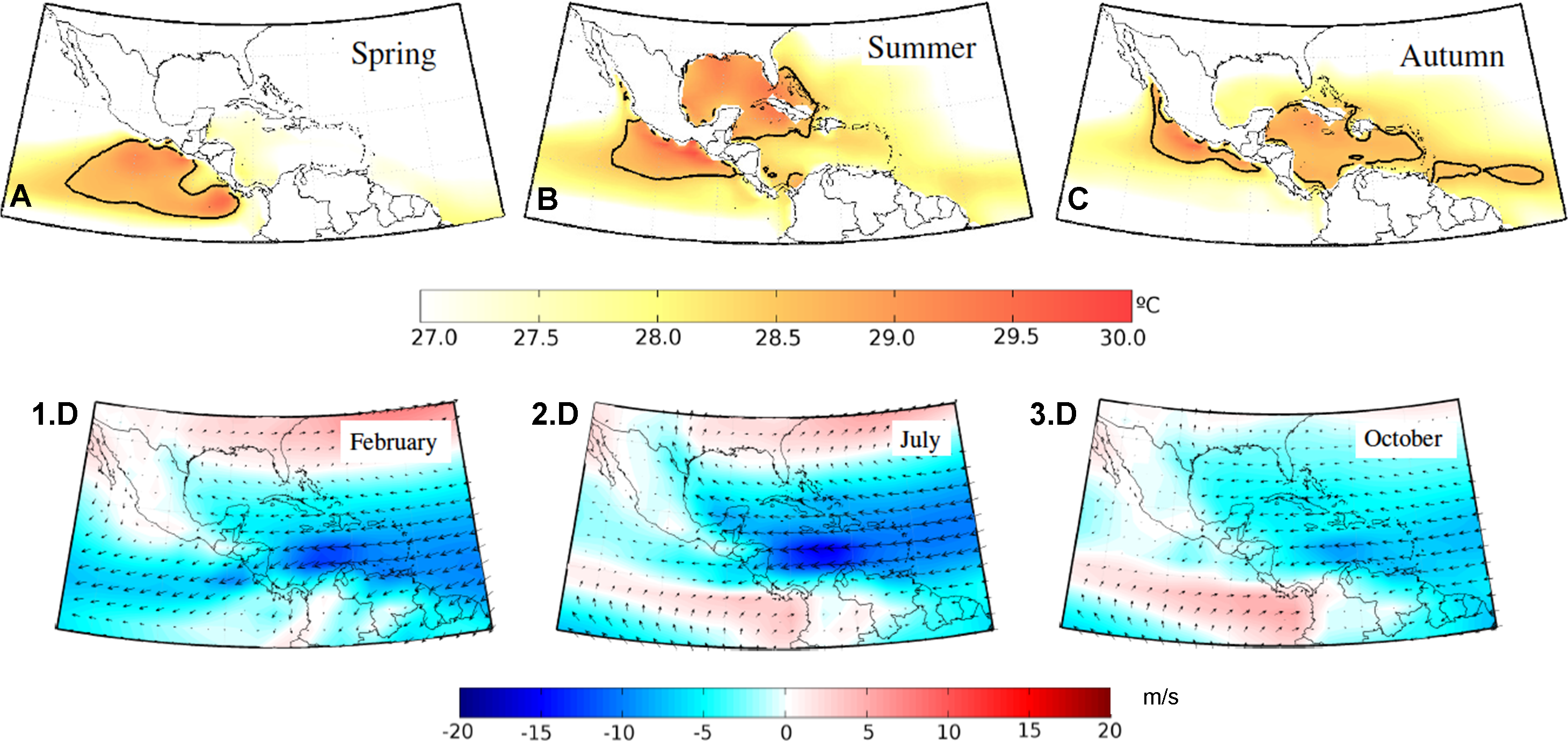
1. IntroductionTropical mountainous ecosystems are recognized as providers of valuable ecological and hydrological services (Viviroli et al, 2007). In Central America, the Páramo, a high‐elevation tropical grassland ecosystem, extends over ~ 200 km2 in Costa Rica and Panama, with ~50% of this area located within the Chirripó National Park between 3,100 and 3,820 m asl (-83.49°, 9.46°). Vegetation mostly consists of 0.5 to 2.5 m tall bamboo dominated (Chusquea subtessellata ) grasslands, covering up to 60% of the total Páramo area in Costa Rica (Fig.1a). The climate is controlled by the northeast trade winds, the latitudinal migration of the Intertropical Convergence Zone (ITCZ), cold continental outbreaks (i.e., northerly winds), and the seasonal influence of Caribbean cyclones. These circulation patterns produce two rainfall maxima on the Pacific slope, one in June and one in September, which are interrupted by a relative minimum between July-August, known as the Mid-Summer Drought, due to intensification of trade winds over the Caribbean Sea (Magaña et al., 1999; Waylen, 1996). The wettest season extends from May to November (contributing up to 89% of the annual precipitation), whereas the driest season is from December to April (Fig. 2a; Esquivel-Hernández et al., 2018). The surface water system of Chirripó is characterized by a lake district which comprises approximately 30 lakes of glacial origin and streams flowing down the Caribbean and Pacific slopes (Fig 1b). Lake catchments are characterized by steep slopes that promote rapid hydrological responses such as fast water‐level changes. Input of water to these glacial lakes is mostly controlled by the seasonal inputs of rainfall, which mix up with stream and subsurface waters. In April 2015, the Chirripó Hydrological Research Site (CHRS) was installed with the goal of advancing the understanding of the hydrological functioning in the Central American Páramo using environmental tracers (i.e., water stable isotopes) in combination with hydrometric data. A detailed map of CHRS is available in Esquivel-Hernández et al. (2019).
Numerous socio-economic activities depend on the seasonal rainfall and groundwater recharge cycle across the Central American Isthmus. Population growth and unregulated land use changes resulted in extensive surface water pollution and a large dependency on groundwater resources. This work combines stable isotope variations in rainfall, surface water, and groundwater of Costa Rica, Nicaragua, El Salvador, and Honduras to develop a regionalized rainfall isoscape, isotopic lapse rates, spatial-temporal isotopic variations, and air mass back trajectories determining potential mean recharge elevations, moisture circulation patterns, and surface water-groundwater interactions. Intra-seasonal rainfall modes resulted in two isotopically depleted incursions (W-shaped isotopic pattern) during the wet season and two enriched pulses during the Mid-Summer Drought and the months of the strongest trade winds. Notable isotopic sub-cloud fractionation and near-surface secondary evaporation were identified as common denominators within the Central American Dry Corridor. Groundwater and surface water isotope ratios depicted the strong orographic separation into the Caribbean and Pacific domains, mainly induced by the governing moisture transport from the Caribbean Sea, complex rainfall producing systems across the N-S mountain range, and the subsequent mixing with local evapotranspiration, and, to a lesser degree, the eastern Pacific Ocean fluxes. Groundwater recharge was characterized by a) depleted recharge in highland areas (72.3%), b) rapid recharge via preferential flow paths (13.1%), and enriched recharge due to near-surface secondary fractionation (14.6%). Median recharge elevation ranged from 1,104 to 1,979 m asl. These results are intended to enhance forest conservation practices, inform water protection regulations, and facilitate water security and sustainability planning in the Central American Isthmus.