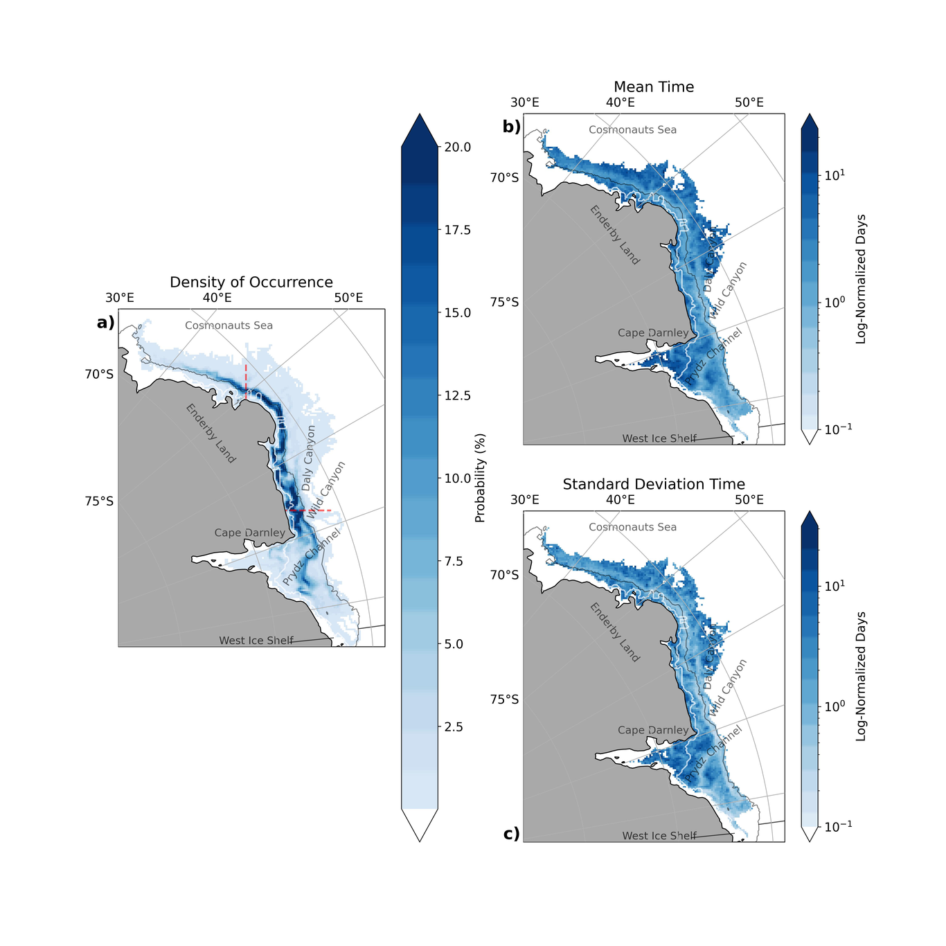
Kieran Murphy

and 43 more

Climate change could irreversibly modify Southern Ocean ecosystems. Marine ecosystem model (MEM) ensembles can assist policy making by projecting future changes and allowing the evaluation and assessment of alternative management approaches. However, projected future changes in total consumer biomass from the Fisheries and Marine Ecosystem Model Intercomparison Project (FishMIP) global MEM ensemble highlight an uncertain future for the Southern Ocean, indicating the need for a region-specific ensemble. A large source of model uncertainty originates from the Earth system models (ESMs) used to force FishMIP models, particularly future changes to lower trophic level biomass and sea ice coverage. To build confidence in regional MEMs as ecosystem-based management tools in a changing climate that can better account for uncertainty, we propose the development of a Southern Ocean Marine Ecosystem Model Ensemble (SOMEME) contributing to the FishMIP 2.0 regional model intercomparison initiative. One of the challenges hampering progress of regional MEM ensembles is achieving the balance of global standardised inputs with regional relevance. As a first step, we design a SOMEME simulation protocol, that builds on and extends the existing FishMIP framework, in stages that include: detailed skill assessment of climate forcing variables for Southern Ocean regions, extension of fishing forcing data to include whaling, and new simulations that assess ecological links to sea-ice processes in an ensemble of candidate regional MEMs. These extensions will help advance assessments of urgently needed climate change impacts on Southern Ocean ecosystems.

Margaret Murakami

and 3 more

Antarctic Bottom Water (AABW) forms the deepest limb of the meridional overturning circulation (MOC) and is a key control on global exchanges of heat, freshwater, and carbon. Density differences that drive the MOC have their origin, in part, in coastal polynyas. Prydz Bay polynyas in East Antarctica are a key source of Dense Shelf Water (DSW) that feeds AABW to the Atlantic and Indian Oceans. However, several poorly understood mechanisms influence the pathways and change water mass properties of the DSW on its way to the abyss. To better understand these mechanisms, we release Lagrangian particles in a 10 km resolution simulation of the Whole Antarctic Ocean Model and analyze the resulting tracks using novel cluster analysis. Our results highlight the role of mixing with other water masses on the shelf in controlling the fate of DSW and its eventual contribution to AABW. When advected beneath the ice shelf, DSW can mix with fresh Ice Shelf Water (ISW), becoming less dense and making future AABW formation less likely. This study confirms that towards the shelf break along the Antarctic Slope Current, mixing with circumpolar deep water (CDW) forms modified circumpolar deep water (mCDW) and influences DSW export as AABW. Our findings indicate that the pathway from DSW to AABW is sensitive to mixing with ambient waters on the shelf. An important implication is that with future increase in ice shelf melt and CDW warming, AABW production is likely to decline, even if DSW production in coastal polynyas remains constant.

Stefanie Mack

and 8 more

The ice sheet-ocean modeling community is making large strides toward developing coupled models capable of examining the interactions and feedbacks between ice shelves and ocean along the Antarctic margin. We present preliminary results and address some of the challenges that have arisen during the development of a coupled ice sheet-ocean model. The ice sheet model is icepack, a shallow-shelf finite element model written in Python. The ocean model is the Regional Ocean Modelling System (ROMS), a terrain-following vertical (sigma) coordinate model that has been modified to interface with a moving ice shelf. These two models are coupled in an online configuration using the Framework for Ice Sheet Ocean Coupling (FISOC). The use of a model with sigma coordinates for the ocean component introduces a simplification and a complication to modeling a moving ice draft. The sigma coordinate system retains the same number of vertical layers at any depth, eliminating the need to convert grid cells between ice and water, when using a fixed grounding line configuration. However, as the ice shelf draft evolves in time, topographic configurations develop that induce pressure gradient errors in ROMS. We quantify these errors in an idealized set-up with an artificially changing ice draft following the ISOMIP+ geometry. We compare results between an ice draft that is smoothed to meet standard ROMS smoothing criteria (rx0, rx1) and a non-smoothed ice draft. Finally, we present a simple parameterization in a buffer zone near the grounding line that uses interpolated melt rates from the ocean model, allowing us to maintain a steep ice topography in the ice model without inducing pressure gradient errors in the short water column in the ocean model. This model configuration will be applied to Pine Island Glacier and used to examine present and possible future states of the ice sheet-ocean system.